|
|
|
Towns and Trading in the Viking Age
Norse traders (and raiders) traveled extensively throughout the known world, bringing back to the Norse lands a wide variety of trade goods. The capacity of Norse era cargo ships made it possible to trade not only in high value luxury items (such as silks and spices from the Far East), but also in more bulky, prosaic, every-day items.
|
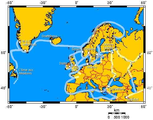
Most of the trading was over short distances, to and from dozens of ports around the Scandinavian coasts. But a smaller number of international trading centers grew, attracting merchants from throughout Europe, the Arab states, and even Asia. The map shows some of the major Norse trade routes, as well as a few of the important Norse trading centers, settlements, and navigational points. |
 |
Some of the exports from various regions during the Viking age include:
Vínland: timber
Greenland: walrus ivory, furs, skins, wool
Iceland: fish, animal fat, wool cloth and clothing, sulfur, falcons
England: tin, wheat, honey, woolens, silver, barley, linen
Russia: slaves, furs, wax, honey
Byzantium: silks, fruits, spices, wines, gems, silver, jewelry, brocade
Frankish kingdoms: weapons, jewelry, wine, glass, salt, woolen cloth
Shetland Islands: soapstone
Norway: timber, iron, soapstone, whetstones, barley, tar
Sweden: iron, furs
East Baltic regions: amber, slaves, furs
Little is known of the details of trade in the Viking age. Probably most is known about Icelandic trade, because of the surviving law books and stories in which trade is described.
Most Norse merchants were not professionals. They were first and foremost farmers, and their main income came from agriculture and property rentals and taxes and fees. Rather than sending a representative, traders traveled with their goods. Since virtually all trade was done through barter, the merchant wanted to personally verify the quality and quantity of goods received in trade.
 |
On trading journeys, the entire crew consisted of traders. In a sense, even passengers were traders, since they paid for their passage with trade goods. Each trader was entitled to an equal allotment of cargo space on board ship for their goods. The traders paid the captain or the ship's owner for the cargo space. The captain received a larger space in order to take merchandise that could be traded for ship's gear, should the need arise during the voyage. Great care was taken to evenly divide the labor on board the ship during the voyage. Everyone on board was considered a member of the crew and was expected to help, including passengers. Thus, the crew's anger is understandable when Grettir refused to help with any of the shipboard chores, as described in chapter 17 of Grettis saga. Only by paying a fee could someone on board ship avoid these responsibilities. Grettir refused to pay and refused to work. |
|
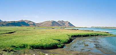
Trading voyages to or from Iceland typically sailed in one direction during the first summer, wintered over, and then returned the following summer. Ships were pulled up on-shore in the fall for the winter. The law required all farmers in the district (with few exceptions) to help with the chore of pulling a ship on-shore in the fall, and relaunching the ship in the spring. In Viking age Iceland, many harbors were used for trade throughout the country. Ships were beached in rivers, estuaries, and in trenches (í sík), according to chapter 39 of Egils saga. One major trading area was along the banks of Hvitá at Borgarfjörður. The location of the trading center as it appears today is shown in the photo to the right. Egil's son, Böðvarr drown when his boat overturned in the fjord while returning from this marketplace to his home. This death led to Egil's composing his most moving poem, Sonatorrek. |
 |
All traders on board a ship paid a harbor tax to the owner of the dock area. In exchange, the owner provided access to water and pasturage for the horses of the traders' customers, as well as providing storage space for goods. In addition, the captain of the ship paid a dockage fee to the landowner.
In Iceland, the prices for a merchant's goods was customarily set by the local chieftain (goði), a situation which seems doomed to lead to disagreements between merchants and chieftains.
|
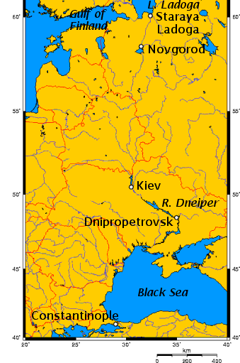
The extent of the eastern trade routes in the Viking age is remarkable. Norsemen traveled to Byzantium to connect with traders from Arabia, Africa, and the Far East. There were two main trade routes through Russia, both of which required that the ships be dragged up rapids and portaged overland. In addition, there were two trade routes through central Europe to the Baltic. The primary trade route through Russia began in the Gulf of Finland. Traders sailed into Lake Ladoga to a trading center near the present location of Staraya Ladoga, a major Swedish trading center in the 9th and 10th centuries. Traders sailed south along the river Volkhov to Lake Ilmen and the stronghold at the present location of Novgorod. From there, ships were rowed up the Lovat or other rivers and hauled overland to either the Volga (for those heading to the Caspian Sea) or the Dnieper (for those heading to the Black Sea). Several fortified towns grew along the shores of the Dnieper, including one at the present site of Kiev. Below Kiev, the Dnieper passes through rocky gorges and cataracts near Dnipropetrovsk. In some cases, the cargo was left on board, and the ships were guided through the rapids by men with poles. In some cases, the cargo was removed, and the ships were dragged overland around the rapids. These places were obvious spots for ambushes, so traders took elaborate precautions to guard their merchandise and themselves. |
 |
 |
Towns typically appeared along the main trading routes early in the Norse era. They were centers of transshipment, exchange, and redistribution. Professional craftsmen and smiths were naturally drawn to these locations to practice their crafts. Towns were distinguished from villages by the presence of these traders and craftsmen. Agriculture was of secondary importance to town residents. They made their living by making and selling their goods, rather than consuming them themselves. It has been difficult to determine whether these settlements were seasonal, or permanent. Excavations at Kaupang from 1956-1967 indicated only seasonal occupancy, since no evidence of hearths in the excavated houses was found. However, excavations in the summer of 2000 found ample evidence of houses with hearths, which suggests year-round occupancy. The depth of the refuse pits and the number of graves on the site also suggest that the site was a permanent settlement. |
Towns sprung up in places that were easy for traders to reach by both land and sea. Since the concentration of valuable articles would be tempting to any raider, towns tended to be located in strategic points, where they could be defended. Royal protection and support was important in the development of towns. A guarantee of peace and order was necessary for the marketplaces, otherwise merchants would stay away. Regional kings or chieftains provided the traders with protection from pirates, while the traders filled the royal coffers with tolls and taxes. The chieftain also provided the authority needed to organize and set up the town, allocating permanent plots of land to families. The chieftain's hall at Kaupang was partially excavated in the summer of 2000. The site of the hall is on a hill outside the town, with a commanding view of the town and the roads approaching it.
|
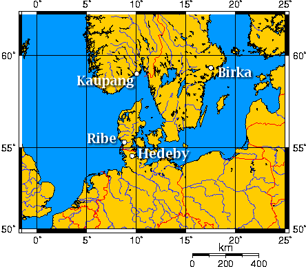
The map to the right shows the location of four of the main trading centers in the Norse era. Hedeby was founded by the Danish King Godfred in the year 808, when he forced merchants to move from the older trading center, Reric, to the new town of Hedeby. This move was forced to ensure that the lucrative trade routes were brought within Godfred's borders. Hedeby was situated on Jutland, on a well protected site in the inner part of the Schlei fjord. Here, it controlled both the north/south trade routes (between Europe and Scandinavia) and the east/west routes (between the Baltic and the North Seas). It was directly on the Schlei fjord which communicates with the Baltic sea, and only a few kilometers from rivers which communicate with the North Sea. Less than 1km away was Hærvej (the Army Road), the main north-south land route in Jutland. Hedeby was known from Iceland to Baghdad. It was called Sliesthorp, Æt Hæthum, Haithabu, and Hedeby. |
 |
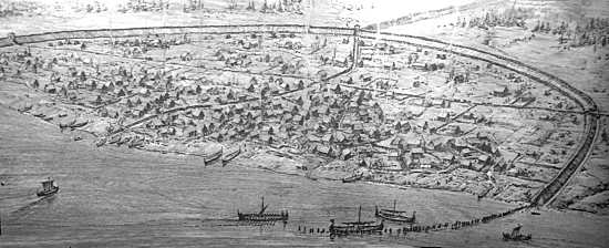
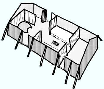
Although
earlier settlements had existed at the site, the Norse town was
clearly planned (sketch below). Wood-paved streets were laid out on a regular
perpendicular grid. The creek which ran through the site was channeled.
A semicircular earth and timber wall surrounded and protected
the town. The wall was 1.3km (0.6 miles) around, and 5.1m (16
feet) high. The only entrances to the town were through the two
gates to the north and south, and from the harbor on the fjord. The harbor had several causeways and a semi-circular palisade
for defense. The wall enclosed an area of approximately 24 hectare (60 acres).
Soil conditions at Hedeby favor the preservation of some types of objects, so archaeological excavations have yielded a fairly clear picture of the town and its inhabitants.
|
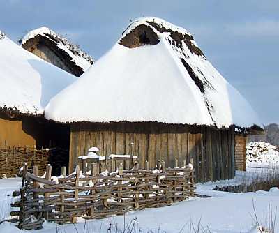
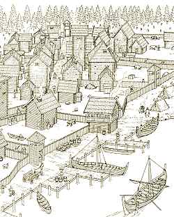
Roofs of houses nearly met across the narrow, wood paved roads. Within the town, in addition to trade facilities, were manufacturing facilities. Iron, precious metals, leather, wood, textiles, and bones were worked inside the walls of Hedeby. There was even a mint for striking coins. Residents of Hedeby included traders, sailors, and smiths of all sorts. People lived in houses on small, fenced plots. Most houses had a well and an outhouse, and many had other outbuildings. A modern recreation of a house at Hedeby is shown to the right. |
|
 |
A sketch of the floor plan of a house excavated in Hedeby is shown to the left. Through dendrochronology (the dating of objects based on tree ring patterns), it was possible to determine that the trees used for the house were cut in the year 870. The house measured 5 by 12 meters (16 by 40 feet). The central room was the main living quarters, for cooking, living, and sleeping, having the typical central fire pit and raised benches along the walls. The room to the left contained a domed cook oven and storage space. Food for the town was imported from nearby farms. The room to the right was a workshop, with a window in the gable for light. Archaeological evidence suggests that workshops were kept neat and tidy. Broken tools and molds and other debris are typically only found outside the workshops, in midden heaps. |
 |
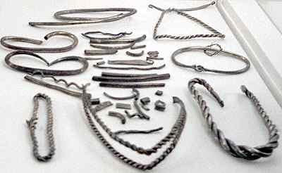
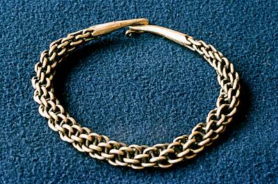
Trading was usually accomplished by barter. In addition, silver was used as a medium of exchange, in the form of coins, unworked silver rods, and in the form of jewelry. The value of silver was based solely on its weight. |
 |
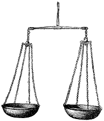 |
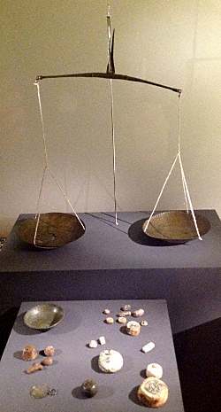
Viking traders used weights sets and bronze scales, some of which folded up on themselves, making for a very compact package for traveling. A more conventional Viking age scale and weight set is shown to the right. |
 |
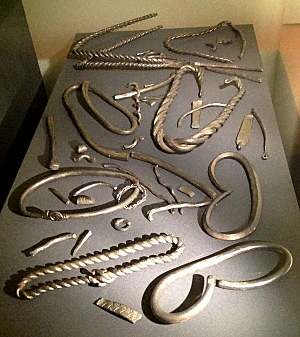 |
If the weight of a piece of jewelry was more than needed to complete a purchase, it was cut into bits to make up the correct weight for the transaction. Thus, many of the silver hoards contain pieces of "hack silver": silver jewelry that had been cut up in order to complete a purchase. |
|
During the early part of the Viking age, most of the silver was acquired from Arab lands, on trade routes through Russia. Towards the end of the 10th century, trade routes changed, and the silver mines near Baghdad ran dry. Silver from the Harz mountains in central Germany began to replace the Arab silver. Some Norse lands were very wealthy during the height of the Norse era. This wealth was due not only to the profits from trading, but also due to the treasures brought back from raids, and from the payments made by rulers in other parts of Europe simply to prevent future Norse raids. In Anglo-Saxon England, these payments were called Danegeld. It is estimated that in the 25 years at the end of the 10th century and beginning of the 11th century, more than 150,000 pounds (68,000 kg) of silver was paid by the English to the Danes. |
 |
The equivalent value of silver obviously varied from place to place and time to time. At the beginning of the 11th century in Iceland, the approximate exchange rates were:
8 ounces of silver | = | 1 ounce of gold |
8 ounces of silver | = | 4 milk cows |
8 ounces of silver | = | 24 sheep |
8 ounces of silver | = | 144 ells (about 72 meters) of homespun woolen cloth 2 ells wide (about 1 meter) |
| 12 ounces of silver | = | 1 adult male slave |
In the Norse era, an ounce (eyrir, plural aurar) weighed 27g, nearly identical to the modern avoirdupois ounce. Eight ounces made up one mark.
In Iceland, standard homespun woolen cloth was adopted and used as a medium of exchange. In the medieval Icelandic lawbook Grágás, many of the payments are listed in ounce-units (aurar) of homespun, the amount of homespun woolen cloth that could be purchased with an ounce of silver. The laws specified the quality and dimensions and measurement techniques of standard cloth in several grades (e.g., Grágás St 261), as well as the penalties for false measures.
|
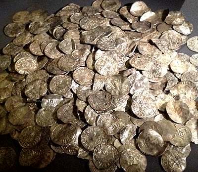
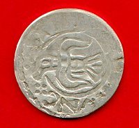
Coins typically took the form of silver pennies, minted in many locations throughout the Norse region. (The coin shown to the right was minted in York, England, around the year 940. The dies for this coin survived as well.) Although about the same diameter as a modern U.S. or British penny, Norse era coins were much thinner, weighing a bit more than one gram (0.04 ounces). As with other silver, a coin's value was determined by weight. Minting the silver by impressing the king's mark into the coin only served to guarantee its purity, not its weight. The actual purity varied from one king to the next. Norse silversmiths had the ability to refine silver to a level of about 99% purity. In some cases, impurities were added to make the silver harder, while in other cases, impurities were added to debase the value of the silver. Relatively pure silver was called brannt silfr (burned silver), while debased silver was called bleikt silfr (pale silver). |
 |
When this coin was minted, the silver was relatively pure. Later, in order to reduce the impact of the Danegeld payments on England's purse, the coinage was debased, and the silver content was considerably reduced. During the rule of the Norwegian king, Haraldr harðráði, the silver content of his coins was reduced from roughly 90% (the norm in other lands) to about 33%. In chapter 30 of Morkinskinna, when Halldórr Snorrason received his pay from the king in debased coins, he contemptuously swept the coins into the straw on the floor. Later, he said, "Why should I serve him any longer when I don't even get my pay in genuine currency?" Eventually, King Haraldr paid him in pure silver.
Because of the rise in water level since the Norse era, many of Hedeby's wooden structures are well preserved. Archaeological digs in Hedeby's six cemeteries, within the walled city, and in the harbor have greatly increased our knowledge of the Norse era. Dendrochronology (counting tree rings in the lumber) has permitted dating of many of the wooden structures to within an accuracy of one year.
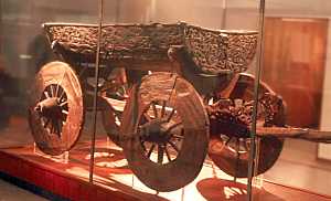 |
One puzzling aspect for me: archaeological evidence suggests that Norse era towns had piers in the harbor. Yet archaeological evidence also shows that at least some Norse era ships had features making it unlikely that they ever would be tied up at a quay. Tholes, cleats, and shield rails all would be vulnerable to damage when alongside a jetty. It's been suggested that ships were moored to posts in shallow water and then unloaded by men wading through the water, or by carts driven into the water, similar to the cart shown to the left found in the Oseberg burial site. Alternatively, ships may have been pulled up onto the beach and unloaded. |
Hedeby was probably the largest town in the Norse lands. Yet, at its peak, Hedeby's population was probably fewer than 1000 people. Today, Hedeby is farmland within the borders of Germany.
|
|
©1999-2026 William R. Short |